| By K. Lee Lerner |
Within the scientific community, in accord with long-established atmospheric physics and chemistry, most climate change predictive models show that as global temperatures increase, at least with regard to tropical waters located between 30 degrees north and south of the equator, extreme precipitation events in the form of tropical cyclones (in the Atlantic Basin, hurricanes) and other storms are likely to increase both in frequency and in the amount of rainfall these storms produce.
Using an Accumulated Cyclone Energy (ACE) index that incorporates factors such as the number of hurricanes, the wind speeds observed in storms, and the lifespan of tropical systems within a particular season, National Oceanic and Atmospheric Administration (NOAA) scientists argue that there have been 17 above-normal Atlantic hurricane seasons over the last 30 years. While there are not statistically more hurricanes, there are more major Category 4 and 5 hurricanes. Moreover, when hurricanes do form, they last longer and drop more rain.
For more information on hurricanes, check out the portal page in Gale In Context: Science.
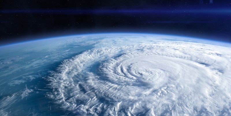
Hurricane Helene made landfall in Florida on September 26, 2024, as a Category 4 major hurricane on the Saffir-Simpson scale. As the system lost wind speed and degraded to a tropical storm, it lashed its way northward through Georgia, South Carolina, North Carolina, and eastern Tennessee, becoming the deadliest hurricane to hit the U.S. mainland since Hurricane Katrina in 2005. As of October 14, 2024, the storm was blamed for killing at least 234 people across six states.
A second major and rapidly intensifying hurricane, Milton, reached Category 5 status before making landfall on October 9, 2024, on the west coast of Florida as a powerful Category 3 storm. Both hurricanes Helene and Milton formed in hotter-than-normal Gulf of Mexico sea surface temperatures (SSTs).
To the north of the developing tropical cyclone that became Hurricane Helene, and days prior to its landfall, a series of slow-moving storms drew large amounts of tropical moisture from Helene’s outer bands, forming a stationary cold front. These storms dumped large amounts of rain from Atlanta into the southern Appalachian region, including a large area of western North Carolina, in advance of the heavy rains embedded within Hurricane Helene. This one-two punch of rainmakers produced catastrophic flooding.
Check out the in-depth coverage of floods in Gale In Context: Environmental Studies.
The mountainous terrain of the Appalachian region funneled rainwater into streams and rivers that quickly overflowed their banks to form fast-moving flash floods that swept away roads and buildings. The damage to roads isolated people and hampered both rescue and recovery efforts.
North Carolina’s Department of Transportation identified more than 5,400 road sites damaged by rock, mud, and debris from landslides triggered by the heavy rainfall. Weeks after the storm hit, thousands remained without power, cell phone service, and access to potable (drinking) water.
Hurricane Milton formed from a tropical depression in the southern part of the Gulf of Mexico. As it moved over warm Gulf waters, the system experienced explosive intensification to a strong Category 5 hurricane before it slammed into the western side of the Florida peninsula as a Category 3 major hurricane. In terms of low pressure, Milton was the second-most intense Atlantic hurricane ever recorded over the Gulf of Mexico. Only Hurricane Rita in 2005 was stronger. Milton was also the 5th strongest hurricane ever recorded.
Like a buzz saw, Milton downed trees, cut power lines, and scattered debris (some of it left over from damage caused by the outer bands of Hurricane Helene) as it swept inland. Milton’s powerful storm surge hit south of the low-lying and heavily populated Tampa Bay area, but the system generated record flooding and deadly tornadoes over the entire peninsula as it swept across the state and then out into the Atlantic. As of October 14, 2024, the death toll in the United States from Milton stood at 24 people killed.
There are many reasons why hurricanes form and rapidly intensify, and their interactions are complex, but increases in SSTs substantially raise their likelihood. Hurricanes are fueled by warm water and they require SSTs above 79 degrees Fahrenheit (26 degrees Celsius) to form and strengthen.
Climate models predict that as water temperatures rise in response to global warming, extreme storms will increase in frequency. Based on observed global warming to date, rapidly developing and intensifying hurricanes like Helene and Milton combining with extreme rainmaker storms is a weather phenomenon now anticipated to occur about once every eight years (i.e., about three events over a 25-year period) in coastal regions and once every 70 years farther inland. The Global Warming and Climate Change portal page provides detailed information on this topic in Gale In Context: Science.
A weather phenomenon likely to reoccur every 70 years may still sound rare, but not when one considers that just a few decade ago such storms were predicted to occur about once every 140 years. Ominously, the next few more tenths of a degree of global warming could easily increase expected rainfall by as much as 15 to 25 percent while simultaneously shrinking the expected interval between such events to once every 30 years.
 About the Author
Recognized for his use of language, accuracy, and balanced presentation, K. Lee Lerner’s portfolio covering science and global issues for Cengage includes two ALA RUSA Book and Media Awards and two works named Outstanding Academic Titles. Holding degrees in science, education, and journalism, including a master’s degree with academic honors from Harvard, Lerner has served on the board of advisors for the venerable American Men and Women of Science since 2003 and, along with Brenda Wilmoth Lerner, as coeditor for three editions of the Gale Encyclopedia of Science. He was the contributing editor-in-chief for Gale’s Encyclopedia of Espionage, Intelligence, and Security. A member of the National Press Club in Washington, DC, Lerner is an experienced aviator and sailor who has completed two global circumnavigations. His Academia site consistently ranks among those most frequently accessed by students, scholars, and decision-makers from around the world. Additional information may be found at https://scholar.harvard.edu/kleelerner and https://harvard.academia.edu/KLeeLerner/